Thank you and welcome back to this week's post on the Civil Biz, this week I would like to talk about the new surveying tech - the RIEGL Terrestrial Laser Scanner.
Throughout the history of surveyors, there have been instruments used to measure distances (Gunter Chain, Total Station and even GPS). Each were designed to measure the distance from point A to point B accurately for the time that each instrument was used. Now, there is yet another generation of more-advanced surveying technology coming onto the playing field: RIEGL's Terrestrial Laser Scanner. With every new piece of tech that comes out, people will want to play with it, see how it works; but for businesses, they will want to know how the product really performs, so they can best decide whether or not to purchase this new product. In this post, I will look into this next generation of surveying equipment, and try to identify the best and worst qualities within the system.
The Terrestrial Laser Scanner (TLS) was originally developed
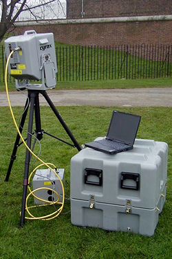
Thus far, there have been four generations of terrestrial laser scanners, and just with the progression of all technologies, the flaws of the first TLS were continuously improved as each new generation came out. The second generation (2002) saw faster data processors integrated into the Scanner, however, the battery and data storage were still outside of the instrument. The third generation (2007) brought select models of TLS that had power and data storage integrated into the instrument, as well as the range and processing speed had improved. Another progression of the third generation was the incorporation of digital images, focused centering systems and reflectors were added to the TLS as a means to allow for closer cooperation with more traditional instruments of surveying (instruments like the total station).
In the fourth generation or the Terrestrial Laser Scanner, the data storage and
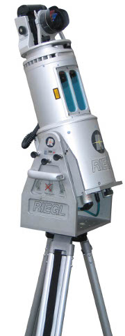
Obviously, the Terrestrial Laser Scanner was designed to map out objects to great detail from greater distances away. This scanner is primarily used in mining operations, detecting where miners have already dug, while helping to plan out future directions of mining. The company RIEGL boasts that their scanner can map objects with a variance of error of only twenty-five (25) millimeters. In my experiences using surveying equipment in class-settings as well as in the field, I have learned that, if anything, one needs to be as close to dead-on accurate to get the desired results. To get the best odds of recording the most precise information, I would place my bets on an instrument that is accurate within twenty-five millimeters.
Another important benefit of the new generation of RIEGL Terrestrial Laser Scanners is the versatility that the instruments can be used with. RIEGL has designed several different forms and models of its' TLS, so that consumer companies and industries will be able to modify an automobile, sea-bearing vessel or even unmanned aerial vehicles fitted with terrestrial laser scanners. The benefit of this is that companies/industries will now be able to take company vehicles out and survey locations without leaving the vehicle - kind of like what Google did with Google Maps. With this modification, companies/industries will be able to survey surrounding landscape/waters or collect aerial maps of construction/mining sites with ease. The concept is very intriguing and leaves me wondering how long it will be until the human element of surveying is phase out all together?
All together, RIEGL has finally redesigned their Terrestrial Laser Scanner to something that I think would be beneficial for all companies to use. The scanner is versatile, capable of being easily moved from location to location; the efficiency of the scanner has grown exponentially, now being able to process vasts amounts of data very quickly; also, RIEGL has expanded the practical uses of their scanner to the uses of being modified to land, sea and air vehicles. To whatever the task, RIEGL's Terrestrial Laser Scanner is your best bet to a quality job. For more information, one should investigate RIEGL's website at: http://www.riegl.com/nc/products/terrestrial-scanning/.
Until next week!
~Civil Biz
As a fellow civil engineer, I am somewhat familiar with the technology used in surveying. I myself even wrote about a new automatic level being used in the field. Your analysis of the TLS gave the reader a very thorough idea of how the design began as well as the progression within the technology from 1990-present. You also did a nice job presenting the information in a way that was technical to the machine's abilities, but not too technical for a general audience. Great job on this post!
ReplyDeleteThe overall format of this was great. Being from a veterinary background I was slightly lost in the idea of this though. Maybe it was because I don't have the knowledge for this. I think it's crazy the different things you can do in this field. I also liked how you put pictures of what you were talking about in the blog!
ReplyDelete3d laser scanning services Calgary, Alberta exceedingly gainful in diminishing time to showcase another item by utilizing late innovation headways. It can get the plan knowledge by filtering and structures can be gathered on CAD programming in advanced development.
ReplyDelete